The Winter Way is a Jacobean route that starts in Ponferrada. It ventures into Galicia largely following the river corridor of the Sil River through regions such as Valdeorras and the Ribeira Sacra, until it connects at Lalín/A Laxe with the route that continues towards Santiago.
Its historical identity is understood in contrast to the French Way: in wintertime, the route offered a lower-altitude itinerary that avoided the ascent to the snow-covered peaks of O Cebreiro, reducing the risks associated with mountain weather.
Today, it remains less travelled (which appeals to pilgrims seeking tranquility), but it is well signposted and offers a very strong cultural and scenic profile: Las Médulas, vineyards, Romanesque heritage, and inland viewpoints.
Índice de contenidos
- 1 Before setting out, what you should know
- 2 History, route and winter rationale
- 3 Recommended stages of the Winter Way in 2026
- 4 Points of interest and key services
- 4.1 Ponferrada and the Templar Castle: a medieval-flavoured start
- 4.2 Las Médulas: the Roman landscape defining the first section of the Camino
- 4.3 The Sil River corridor: valley, slopes, and the aesthetic of the river interior
- 4.4 Valdeorras and the gates of the Ribeira Sacra: vineyards, stone, and inland culture
- 4.5 Montefurado: a tangible “test” of the Roman past
- 4.6 Monforte de Lemos and the inner heart: urban history and monumental presence
- 4.7 Codos de Belesar and the visual Ribeira Sacra: meanders, terraces and natural viewpoints
- 4.8 Serra do Faro and Nosa Señora do Faro: the symbolic summit of the Camino
- 4.9 Deza, Lalín and the path to Santiago: transition to a more Jacobean finish
- 5 Comparison with other Jacobean routes
- 6 Practical recommendations for pilgrims in 2026
Before setting out, what you should know
To plan it realistically during the colder months, three facts should be considered:
- There is no single “official” universal list of stages.
- In winter, fewer services are open and there is more logistical uncertainty.
- The route includes points of significant altitude (the Serra do Faro reaches around 1,153 m, the highest point of the route), as well as areas prone to heavy rain and even occasional flooding.
This text is for informational purposes only. Mundiplus does not currently cover the Winter Way. In this case, our sole aim is to provide information about this alternative. If you want to enjoy the experience with us, we invite you to check our alternative Santiago de Compostela routes.
History, route and winter rationale
In fact, the Winter Way can be seen as a “natural entry into Galicia” from the Meseta and has origins linked to the Roman era: a secondary Roman road connected to the gold mines of Las Médulas is documented, with the Roman tunnel of Montefurado cited as evidence.
Later historical layers are also documented. The route was used by different peoples over time: it served as an entry route for Napoleon Bonaparte’s troops in the early 19th century. Subsequently, it became a corridor for the first railway line connecting Galicia with the rest of the Iberian Peninsula in 1883.
As mentioned, the term “Winter” is associated with the practical logic of avoiding a critical point of the French Way: the ascent of O Cebreiro under snowy conditions. Contemporary guides and Jacobean institutions confirm this. It is a way to bypass the climb to the Cebreiro pass/peaks during the harshest winter period, advancing along the sheltered river valleys.
Regarding official recognition, the Xunta de Galicia announced in 2016 the enactment of the Cultural Heritage Law which officially recognises the Winter Way as a pilgrimage route. It stands out as the only route that crosses all four Galician provinces, with a marked path of around 210 km in Galicia (institutional figure) passing through regions such as Valdeorras and Deza.
The full route measures approximately 260–270 km from Ponferrada, allowing for minor variations due to detours, construction, and ecological alternatives (for example, the variant via Serra da Enciña da Lastra).
As a summary of the route for pilgrims (approximate order of major points), the itinerary links: Ponferrada → Las Médulas → O Barco de Valdeorras → A Rúa de Valdeorras → Quiroga → A Pobra do Brollón → Monforte de Lemos → Chantada → Rodeiro → Lalín → Silleda → Outeiro (Vedra) → Santiago de Compostela.
Recommended stages of the Winter Way in 2026
The stages of the Winter Way are not fixed: the Jacobean ecosystem itself offers different “splits”. We suggest an intermediate itinerary. The following table summarises a 12-day proposal:
- Day 1: Ponferrada → Las Médulas (28 km)
- Day 2: Las Médulas → O Barco de Valdeorras (27 km)
- Day 3: O Barco de Valdeorras → A Rúa de Valdeorras (13 km)
- Day 4: A Rúa de Valdeorras → Quiroga (28 km)
- Day 5: Quiroga → A Pobra do Brollón (23 km)
- Day 6: A Pobra do Brollón → Monforte de Lemos (13 km)
- Day 7: Monforte de Lemos → Chantada (30 km)
- Day 8: Chantada → Rodeiro (25 km)
- Day 9: Rodeiro → Lalín (22 km)
- Day 10: Lalín → Silleda (16 km)
- Day 11: Silleda → Outeiro (Vedra) (24 km)
- Day 12: Outeiro (Vedra) → Santiago de Compostela (17 km)
Variants and practical adjustments on the ground
The Winter Way includes historical variants and “micro-decisions” that can affect distance, timing, and safety:
- A significant fork appears after Santalla (in the first stage: here there are “two possible alternatives” that converge near the Cornatel castle area (Alto de Ferreiros) before the descent to Las Médulas).
- The clearest variant (and useful for understanding why checking the map before departure is wise) occurs in the second stage: the pilgrim may detour at Quereño towards the Serra da Enciña da Lastra: 14 km extra compared to the Sil riverside route, although both options meet again in O Barco de Valdeorras.
- In the fifth stage, departing from Quiroga, there is the option to go via “San Clodio, Ribas de Sil” and return to the main route after crossing the bridge further on.
- As you can see, the Monforte–Chantada stage is quite long, with few intermediate services. It can be shortened by staying in Diomondi. In Chantada, there are approximately 103 km remaining to Santiago, making it a possible alternative starting point.
Points of interest and key services
One of the main strengths of the Winter Way is its concentration of heritage and scenery in relatively few days: from El Bierzo to the interior of Galicia along the Sil, the Ribeira Sacra, and finally reaching Santiago de Compostela. Below is a route overview focused on points of interest.
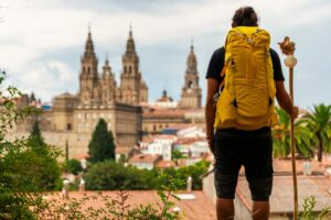
Ponferrada and the Templar Castle: a medieval-flavoured start
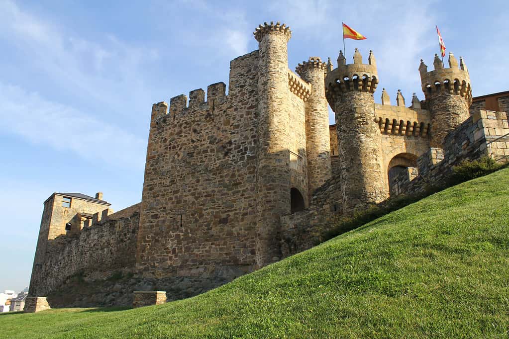
Starting in Ponferrada immediately immerses you in a powerful setting: the city retains a historic frontier atmosphere between paths, rivers, and passes into Galicia.
The major highlight is the Templar Castle, a complex fortress (with multiple phases and renovations) that acts as a “narrative threshold” of the Camino: you leave with a clear medieval image in mind, providing context for what follows. Even if you do not enter, seeing and circling it helps understand why El Bierzo was a strategic territory. It is also a point of interest integrated into the start of the pilgrim’s journey.
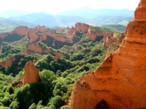
Las Médulas: the Roman landscape defining the first section of the Camino

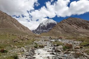
If you had to choose a single “iconic” point on the Winter Way, it would be Las Médulas. This landscape, the result of Roman gold mining, offers something pilgrims highly value: it is not an isolated monument, but an entire territory transformed by history.
The contrast of reddish tones, chestnut trees, and sharply defined shapes makes the place recognisable even under grey skies. Moreover, it fits perfectly with the spirit of the Winter Way: an inland route that “speaks” of Rome, mining, and historic roads, not just cathedrals or large cities.
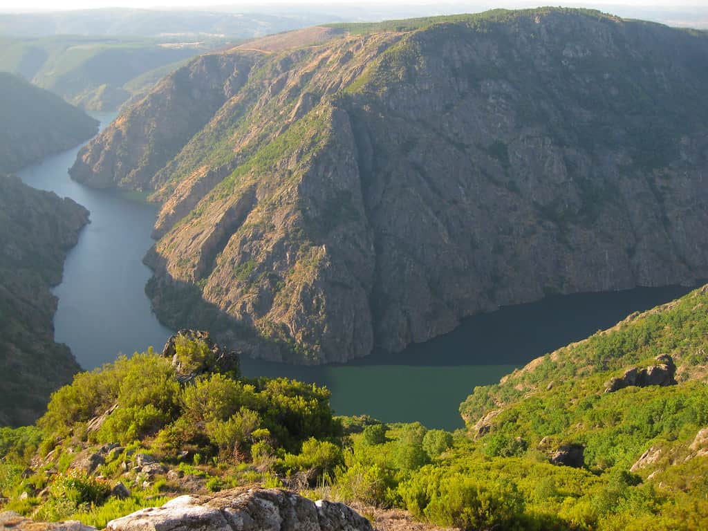
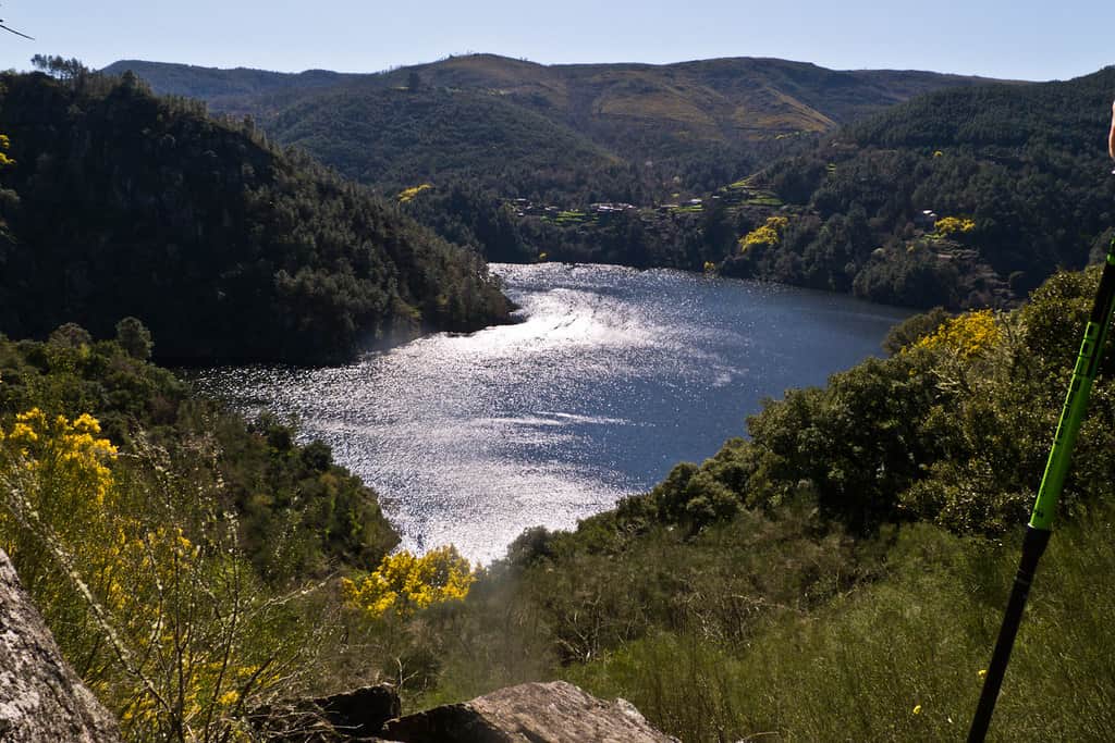
The Sil River corridor: valley, slopes, and the aesthetic of the river interior
From El Bierzo towards Galicia, the route follows the Sil River as a guiding thread. This shapes the experience: stretches of open landscape (valleys) alternate with tighter river curves and slopes, turning walking into an almost “geographical” exercise: you read the terrain as you go.
The interest here is not a single named landmark, but the feeling of a natural corridor: riverbanks, bridges, long views over the water, and changing light under overcast skies. In cold weather, this section offers a particular kind of beauty: austere, wet, and quiet.
Valdeorras and the gates of the Ribeira Sacra: vineyards, stone, and inland culture
Entering regions such as Valdeorras and approaching the Ribeira Sacra universe, the Camino begins to reveal one of its strongest identities: a territory shaped over centuries. Slopes with vineyards, stone walls, small villages, and a landscape combining “human touch” with “rugged nature” appear.
It is not so much a stretch of grand “postcard” monuments as it is scattered heritage: chapels, stone crosses, old cobbled paths in some sections, and views that are earned by walking.
Montefurado: a tangible “test” of the Roman past
On the Winter Way, the Roman connection is not limited to a historical paragraph: it has a tangible presence in the Roman tunnel of Montefurado. This site works very well as a cultural stop because it is concrete and easy to understand: you are standing before a work that reflects ancient engineering and the relationship between the territory and resource exploitation.
On a route that highlights secondary Roman roads and mining connections, Montefurado acts as a “stone argument”: it reminds you that this path, before becoming a pilgrimage route, was a functional corridor.
Monforte de Lemos and the inner heart: urban history and monumental presence
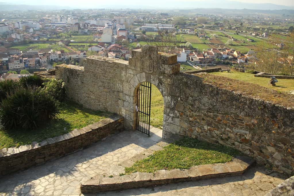
Passing through Monforte de Lemos brings a change of scenery: from more rural and riverine stretches to an area with greater historical density. Here, the interest lies in its character as an inland centre layered with time: Galicia is also this, not just coastlines or grand cathedrals. Depending on how you plan your journey, Monforte is a point where the Camino acquires a more “urban” and monumental tone, with spaces that invite you to look up and read the city as part of the journey.
Codos de Belesar and the visual Ribeira Sacra: meanders, terraces and natural viewpoints
In the section associated with the Ribeira Sacra, one of the names that best summarises the landscape experience is Codos de Belesar: river curves, terraced vineyards, and a hillside aesthetic that impresses with its verticality.
Here, the interest is not “wine tourism”, but observing the heroic vineyard as part of the territory: slopes that explain why inland Galicia can be physically demanding. It is an especially photogenic spot, yes, but also a reminder that the Winter Way combines gentle stretches with others where the terrain asserts itself.
Serra do Faro and Nosa Señora do Faro: the symbolic summit of the Camino
Although the Winter Way was born as an alternative to avoid the snow at O Cebreiro, it is not a “flat” path. The passage through the Serra do Faro represents the high point of the route and offers one of the most mountainous experiences of the itinerary.
We highlight the detour to the hermitage/viewpoint of Nosa Señora do Faro, with that sense of height that completely transforms the landscape: the horizon opens, the light changes, and the route takes on a more “mountainous” tone before returning to gentler areas. This is a section with strong symbolic weight: after several days in the valleys, reaching height is experienced as a psychological milestone.
Deza, Lalín and the path to Santiago: transition to a more Jacobean finish
As you progress through the areas of Rodeiro, Lalín and Silleda, the Camino enters a transitional phase: less riverine epic and more of an “arrival corridor”. The interest here is based on the sense of approach: more open inland landscapes, alternation of woods and rural areas, and the awareness that the route is nearing its conclusion.
Furthermore, the fact that it merges with better-known routes is noticeable in the atmosphere: without losing its identity, the Camino begins to “smell” like Santiago.
Comparison with other Jacobean routes
If the reader reaches this article looking for “the alternative to the French Way for the cold”, the comparison should be made based on operational criteria: altitude, weather exposure, service density, and experience profile (crowds vs solitude).
Compared to the French Way, it is precisely proposed as a variant to avoid the high and potentially snowy passage of O Cebreiro. This motivation appears both in the Galician institutional narrative (route at lower levels of the Sil basin) and in popular Jacobean guides.
In return, there is a clear cost: it is a longer route from the Ponferrada junction. If you choose this option, you will cover approximately 56 km more than the French route. In fact, from Ponferrada it takes 11 stages (not the 12 suggested in this route) to reach Santiago if you choose Mundiplus/en as your travel companion.
In comparison with coastal routes, the Northern Way offers a very different framework.
From Mundiplus/en’s perspective, you can see the stage-by-stage plan in the Northern Way route from Gijón. In winter, the coast usually maintains moderate temperatures, but may be more exposed to Atlantic storms; the Winter Way, on the other hand, is characterised by inland rivers and occasional mountains, with fewer pilgrims and fewer services. To make an informed decision, it is wise to consider three variables: accommodation availability, need for support transport, and tolerance for walking in rain and wind.
It is also important to understand that this route merges with the Sanabrés Way in the Lalín–A Laxe area, and from there shares the itinerary to Santiago. This has a practical effect: in terms of services (hostels, bars, stamps), the final stretch is usually “easier” than the middle section through Ribeira Sacra, precisely because it enters a more trafficked Jacobean corridor.
For those comparing starts on the French Way (due to train/bus availability, variety of hostels, and very mature logistics), Mundiplus/en offers specific guides for classic sections such as the Camino de Santiago from Logroño and the Camino de Santiago from Burgos.
In comparative terms, this route stands out more for its “inland” experience and mining/Romanesque landscape heritage than for service density.
Practical recommendations for pilgrims in 2026
Choosing the Winter Way “for the cold months” is not only a decision of beauty or solitude: it is a logistical decision. Below are specific recommendations, supported by official regulations when affecting the credential/Compostela and route warnings when affecting safety.
- Regarding the best period within the cold season, the most balanced is usually late autumn or late winter/early spring. At these times there is less footfall, and at the same time, the weather is usually less extreme than in the heart of winter. Nevertheless, episodes of snow/ice may occur, requiring adjustments to pace, schedule, and footwear.
- For equipment, the criterion is “managing water and cold”: layers (thermal base + insulation + waterproof), quick-drying trousers, thin gloves, hat/scarf, and above all, protection against persistent rain. On long stages or with few services, it is advisable to carry water and some food to avoid depending on bars closed during the low season.
- Regarding accommodation, the Winter Way does not yet have the “density” of more popular routes. Even institutional sources (Castilla y León) stress that pilgrim support services “are not yet very abundant”. In winter, some establishments may close or operate with reduced hours. Operational recommendation: book when possible in small towns and confirm by phone on the same day if in doubt.
- The credential is essential both for the experience and for certification. The Pilgrim’s Office explains that the official credential is obtained at the office itself or at authorised institutions (parishes, associations, hostels, brotherhoods…) and is required to access hostels and request the Compostela.
- Regarding stamps, there is a practical rule to internalise from day one: the Pilgrim’s Office emphasises the importance of having at least two stamps per day in the last 100 km on foot (and the last 200 km by bike). This should not be a problem in stages with inhabited centres but requires discipline in winter, when fewer establishments may be open.
- In relation to the Compostela, the official rule is clear: 100 continuous km on foot or horseback (200 km by bicycle) on the same official path towards Santiago, and the last stage must be at least the one immediately before arriving at the cathedral. It is also stressed that routes should not be alternated or mixed within the same certified pilgrimage.
- The collection process is also relevant in 2026: the Pilgrim’s Office indicates that the Compostela is delivered in person and individually, free of charge, and that upon arrival at the International Welcome Centre, a registration (via QR) is carried out, after which a code and a ticket number are issued. Opening hours are 10:00 to 18:00 every day, closed 25 December and 1 January.
- If the pilgrim wants a supplementary document, the Pilgrim’s Office provides the “Distance Certificate”, which records data such as start day and point, kilometres completed, arrival day and route. Costs, format, and conditions may vary, so it is prudent to check directly at the office or on its website before travelling.
- For transport, a useful tip is to plan outbound and return trips with a margin: Ponferrada is the usual starting point and the route returns to a larger hub (Santiago), but in winter, any weather incident may affect connections and pace.
- On the route, there are also sections where rain may cause local flooding; therefore, it is advisable to check the official weather forecast each afternoon and avoid walking at night.
- Finally, a “soft safety” recommendation especially valuable on this Camino: carry the offline track and do not rely solely on other pilgrims. The route is described as minoritarian, and that is precisely its charm; but this same feature requires planning with greater autonomy.