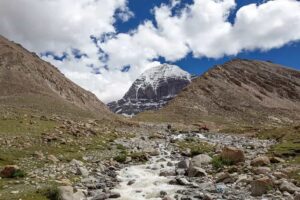
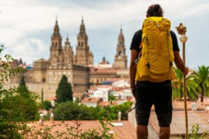
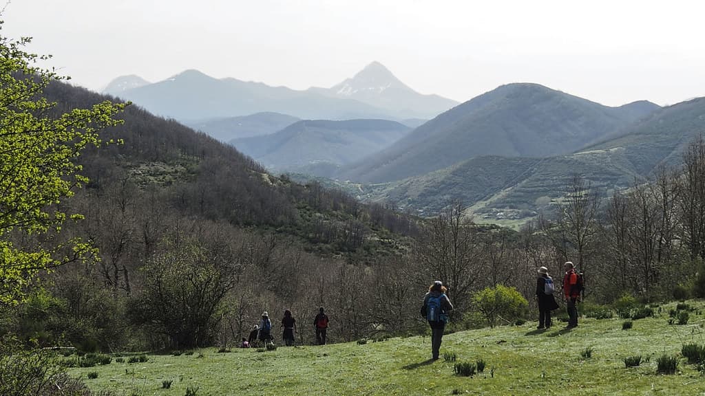
Taking on the Camino de Santiago is a unique experience, but also a challenge that requires preparation. While many associate it with a spiritual and cultural journey, the reality is that walking between 20 and 30 kilometres a day for several days in a row involves a significant physical and mental effort.
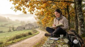
That’s why one of the best ways to get ready is by training with one-day hiking routes that mirror the distance and difficulty of Camino stages. This helps strengthen muscles, accustom joints to impact, and teach you how to manage time, pace and hydration.
In this guide, you’ll discover one-day hikes in Spain and Portugal that are not only beautiful, but also ideal for preparing and assessing whether you’re truly ready for more demanding adventures like the Camino de Santiago.
Índice de contenidos
- 1 Why prepare for the Camino with one-day hikes?
- 2 Top one-day hikes in Spain and Portugal to train for the Camino
- 2.1 Río Borosa Route (Sierra de Cazorla, Jaén)
- 2.2 Route from Santoña to Laredo (Cantabria)
- 2.3 Fageda d’en Jordà and Garrotxa Volcanoes Circular Route (Girona)
- 2.4 Barbate Cliffs Route (Cádiz)
- 2.5 Walk from Porto to Vila do Conde (Portugal)
- 2.6 Ascent to Pico Gilbo (León)
- 2.7 Moncayo Route (Aragón – Castilla y León)
- 2.8 Senda del Oso (Asturias) – Section from Tuñón to Entrago
- 2.9 Ojos Negros Greenway (Valencia – Teruel) – Section from Barracas to Navajas
- 2.10 Médulas Route (León)
- 3 Mountain routes to simulate tough Camino stages
- 4 How to combine routes for progressive preparation
- 5 Practical tips for your training
- 6 From training to adventure
Why prepare for the Camino with one-day hikes?
Training with day hikes doesn’t just boost your fitness. It also helps you:
- Build endurance: walking for several hours without long breaks.
- Get used to carrying a backpack: simulating real Camino conditions.
- Adapt to varied terrain: tarmac, dirt, rock, sand…
- Predict your walking pace: so you know when and where to take breaks.
- Strengthen your pilgrim mindset: learning to enjoy the journey, even in moments of fatigue.
Top one-day hikes in Spain and Portugal to train for the Camino
Río Borosa Route (Sierra de Cazorla, Jaén)
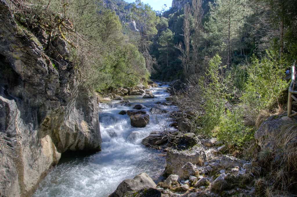
- Distance: 22 km (round trip).
- Elevation gain: 650 m total.
- Best time to go: spring and autumn.
- Type of terrain: mountain trail, footbridges and forest tracks.
Located in the Natural Park of the Sierras de Cazorla, Segura and Las Villas, the Río Borosa Route is a true hiking gem. The path follows the river, crossing walkways, waterfalls and tunnels carved into the rock. The final reward is reaching the Laguna de Aguas Negras, surrounded by stunning high-mountain scenery.
Besides its beauty, this route offers a chance to spot native wildlife like mountain goats or griffon vultures, and admire unique geological formations. It’s a well-rounded trail combining nature, exercise, and a touch of adventure in the heart of the Sierra de Cazorla.
Training here prepares you for stages with moderate elevation, similar to those found towards the end of the Camino from A Guarda to Santiago, where the views will keep you going.
Route from Santoña to Laredo (Cantabria)
- Distance: 25 km.
- Elevation gain: 400 m total.
- Best time to go: spring and summer.
- Type of terrain: coastal trail, beach and low scrubland.
This route blends sea and mountains, with breathtaking views from Monte Buciero and a long stretch along Salvé Beach all the way to Laredo. It’s a varied trail with short climbs, descents, and flat sections.
Along the way, you can visit the Faro del Caballo lighthouse, one of Cantabria’s most iconic spots, and enjoy natural viewpoints offering stunning vistas of the Cantabrian Sea. Gulls and cormorants are commonly seen soaring above the coastline.
It’s reminiscent of the Camino de Santiago from Santander to Gijón, which also takes you along cliffs, fishing villages and expansive beaches.
Fageda d’en Jordà and Garrotxa Volcanoes Circular Route (Girona)
- Distance: 23 km.
- Elevation gain: 450 m total.
- Best time to go: all year round, especially in autumn.
- Type of terrain: forest, rural paths and volcanic trails.
The route passes through the beech forest of Fageda d’en Jordà and climbs volcanic cones like Croscat and Santa Margarida. The mix of dense woodland, open areas and volcanic paths prepares you for the varied stages of the Camino, where terrain often shifts.
This hike immerses you in a unique environment on the Iberian Peninsula, where lush greenery contrasts with the dark tones of volcanic soil. Along the way, you’ll encounter sites of interest like the hermitage of Santa Margarida, nestled in a volcanic crater, and viewpoints offering panoramic views of the Natural Park.
In addition, the soft terrain and shade from the beech trees make it a comfortable route, even for longer walks.
Barbate Cliffs Route (Cádiz)
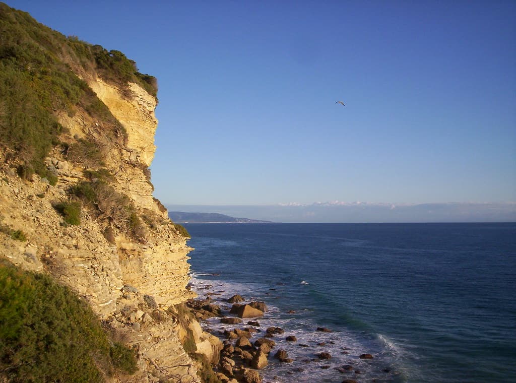
- Distance: 27 km.
- Elevation gain: 350 m total.
- Best time to go: spring and autumn.
- Type of terrain: coastal trail, sand and pine forest.
The route winds through part of the Breña and Barbate Marshes Natural Park, passing cliffs over 100 metres high, pine groves and unspoilt beaches. You’ll learn how to handle hiking in warm and windy conditions — a valuable skill for more exposed Camino sections.
Throughout the hike, you’ll enjoy breathtaking views of the Atlantic from natural lookouts like the Torre del Tajo, a former 16th-century watchtower. The contrast between the deep blue sea and the green pines creates a one-of-a-kind landscape, enhanced by the scent of Mediterranean flora.
The trail also offers the chance to observe migratory birds that use this area as a natural corridor.
Walk from Porto to Vila do Conde (Portugal)
- Distance: 25 km.
- Elevation gain: minimal.
- Best time to go: spring and summer.
- Type of terrain: seafront promenades, sand and urban streets.
This route is actually one of the early stages of the Portuguese Camino from Porto to A Guarda, following the coastal variant. It’s a mostly flat path that runs alongside the Atlantic, alternating between promenades, wooden walkways and long beach sections.
Starting from Porto’s Ribeira district, with its colourful façades, and heading towards Matosinhos while crossing the impressive Leixões drawbridge is quite an experience. From there, the sound of the waves and the sea breeze accompany you all the way to the historic town of Vila do Conde, known for its Santa Clara Monastery and fishing harbour.
This route is perfect for those who want to train endurance on flat terrain and get used to walking for hours in coastal environments, where wind and humidity can play a significant role. In addition, its signage and services make it an excellent opportunity to try out a real Camino stage dynamic in just one day.
Ascent to Pico Gilbo (León)
- Distance: 21–23 km (extended route).
- Elevation gain: 900 m accumulated.
- Recommended season: summer and early autumn.
- Type of terrain: rocky mountain and alpine meadow.
Physically demanding due to its elevation gain, but ideal for building strength and endurance at altitude. Perfect for simulating mountain stages on the Camino Primitivo or areas such as O Cebreiro.
Known as the “León Matterhorn” for its pyramidal shape, Pico Gilbo offers stunning views over the Riaño reservoir and the Cantabrian Mountains. The route combines forest tracks with technical ascents and requires good footwear and some mountain experience.
On clear days, the summit offers panoramic views of peaks such as Espigüete or Mampodre, making the effort truly worthwhile.
Moncayo Route (Aragón – Castilla y León)
- Distance: 20–24 km.
- Elevation gain: 1,000 m accumulated.
- Recommended season: summer and autumn.
- Type of terrain: mountain trail, forest and high-altitude paths.
The ascent to Moncayo is an excellent training ground for stages with steep climbs, strengthening both legs and lung capacity.
Located between Aragón and Castilla y León, this is the highest peak of the Iberian System, reaching 2,314 metres.
The climb takes you through varied ecosystems, from beech and pine forests to high mountain meadows. On clear days, you can see both the Pyrenees and the Meseta from the top. Although challenging, the route is well-signposted and ideal for simulating long, continuous ascents.
Senda del Oso (Asturias) – Section from Tuñón to Entrago
- Distance: 30 km.
- Elevation gain: very low.
- Recommended season: all year round.
- Type of terrain: paved greenway and dirt tracks.
Perfect for training in pure endurance with minimal elevation gain, similar to long, flat stretches of the Meseta on the French Way.
This greenway follows the path of a former mining railway and runs through areas of great natural value, including gorges, tunnels carved into rock, and lush valleys. Along the way, you may spot deer or vultures, and pass by enclosures where the Cantabrian brown bear lives in semi-freedom, giving the route its name.
Thanks to its smooth surface and clear signage, it’s a very safe option for long training sessions.
- Distance: 26 km.
- Elevation gain: 300 m accumulated (downhill).
- Recommended season: spring and autumn.
- Type of terrain: compacted track and rural tarmac.
Ideal for maintaining a steady pace over several hours, while managing hydration and rest effectively.
This section of the Ojos Negros Greenway, Spain’s longest greenway, gently descends from the Barracas plateau to the Palancia River valley, passing viaducts, tunnels and farmland.
The scenery blends pine forests with almond and olive groves, offering a pleasant route in autumn due to the contrast in colours. Its downhill profile allows for a consistent pace over time, ideal for simulating long Camino stages with sustained yet moderate effort.
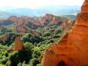
Médulas Route (León)
- Distance: 22–25 km (depending on variant).
- Elevation gain: 500 m accumulated.
- Recommended season: spring and autumn.
- Type of terrain: dirt track, forest path and viewpoints.
Declared a UNESCO World Heritage Site, this unique landscape was once an ancient Roman gold mine and is now one of the most breathtaking locations in León. The route combines wide tracks and paths winding through reddish rock formations, centuries-old chestnut trees, and viewpoints like Orellán, offering the best view of the entire site.
In addition to its beauty, it’s ideal for training on uneven terrain, with gentle ascents and descents, similar to rolling stages on the French Way. It also allows for pace management during hot days, as much of the path is exposed to the sun.
Mountain routes to simulate tough Camino stages
Guadarrama Range Circular Route (Madrid)
- Distance: 20–28 km (depending on variant).
- Elevation gain: 800–1,200 m accumulated.
- Recommended season: late spring to early autumn.
- Type of terrain: mountain trails, rocky ridges and forest tracks.
This route, which can begin from passes like Navacerrada or Cotos, takes in iconic spots such as the Peñalara Lakes, the Cuerda Larga or the Loma del Noruego. Alongside its demanding ascents and descents, it offers spectacular views over the Madrid region and Segovia.
During hot months, high-altitude breezes and pine forest shade help make training more bearable, while in spring and autumn, the changing landscape colours provide extra motivation. It’s the perfect terrain to test footwear, poles, and technical gear in real mountain conditions.
Cares Route (Asturias – León)
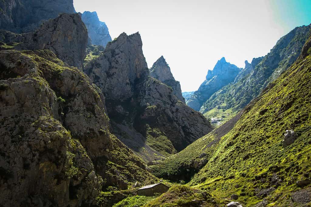
- Distance: 24 km (round trip between Poncebos and Caín).
- Elevation gain: 600 m accumulated.
- Recommended season: late spring to early autumn.
- Type of terrain: rock-carved trail, mountain track and narrow sections.
Known as “the divine gorge”, the Cares Route follows a spectacular gorge carved through the limestone walls of the Picos de Europa. The narrow, winding path offers constant views of the Cares River far below, making the hike as intense as it is photogenic.
The mix of flat stretches and short climbs makes it perfect for working on endurance, while requiring constant focus due to the uneven ground. Along the route, you’re likely to spot mountain goats, see distant snow-capped peaks, and hear the roar of water in natural cascades that line the trail.
How to combine routes for progressive preparation
- Phase 1 – Kilometre accumulation: flat routes of 15–20 km, gradually increasing to 25–28 km.
- Phase 2 – Elevation training: alternate routes with steep climbs and technical descents.
- Phase 3 – Real simulation: backpack with actual weight and 30–35 km stages, using the same footwear and gear you’ll take.
Practical tips for your training
- Plan your routes in advance, reviewing maps and profiles. This helps you understand the distance, elevation, and key points before you set off.
- Take short breaks every hour without letting your muscles cool. Rest enough to hydrate and refuel, but keep the body active to maintain rhythm.
- Vary the terrain to simulate Camino conditions. Switching between tarmac, dirt, sand and uneven trails improves your adaptability.
- Train in the rain or heat to adapt to any condition. You won’t always have perfect weather, so test your physical and mental endurance in all scenarios.
- Use trekking poles if you plan to take them on the Camino. Training with them improves technique, protects your knees and distributes effort more efficiently.
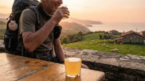
From training to adventure
After weeks of preparation, you’ll be ready to tackle the Camino with confidence. If you decide to take the leap, Camino de Santiago companies like Mundiplus can help with logistics, so all you need to do is enjoy the experience.
Completing one-day routes of 20 to 35 km not only boosts your physical fitness: it also mentally prepares you to enjoy the Camino. From the leafy Borosa Trail to the cliffs of Barbate or the Senda del Oso, every kilometre is a step towards your goal.