The Camino Torres is a lesser-known Jacobean route that connects the city of Salamanca with Santiago de Compostela along approximately 580 km divided into 23 stages. It is a historical route inspired by the journey made in 1737 by Don Diego de Torres Villarroel, a professor at the University of Salamanca. He chose to make his pilgrimage by travelling through Portugal rather than following the busy Vía de la Plata.
Thanks to his knowledge of the Portuguese country (as he had previously been exiled there), he designed an alternative route combining practical and spiritual criteria: avoiding the busiest routes while connecting sites of great historical importance in Spain and Portugal.
Almost three centuries later, this route has been rediscovered and valued by pilgrims seeking a different experience on the Camino de Santiago. Before continuing, please note that this post is purely informative and that this route is not one we offer at Mundiplus, specialists in organised Camino de Santiago trips.
Índice de contenidos
What does the Camino Torres offer?
The Camino Torres, also known as “the Hispano-Portuguese variant”, follows ancient roads and rural paths across Spain and Portugal. Throughout its course, it traverses highly diverse landscapes: the Salamanca dehesas, the Beira Alta region of Portugal, the river valleys of the Douro, Támega, Lima and Miño, before reaching the green estuaries of Galicia.
The route passes through cities and towns steeped in history, some declared UNESCO World Heritage Sites. Among the most notable stops are:
- Salamanca, with its famous Plaza Mayor and cathedrals.
- Ciudad Rodrigo, a walled city of medieval origin.
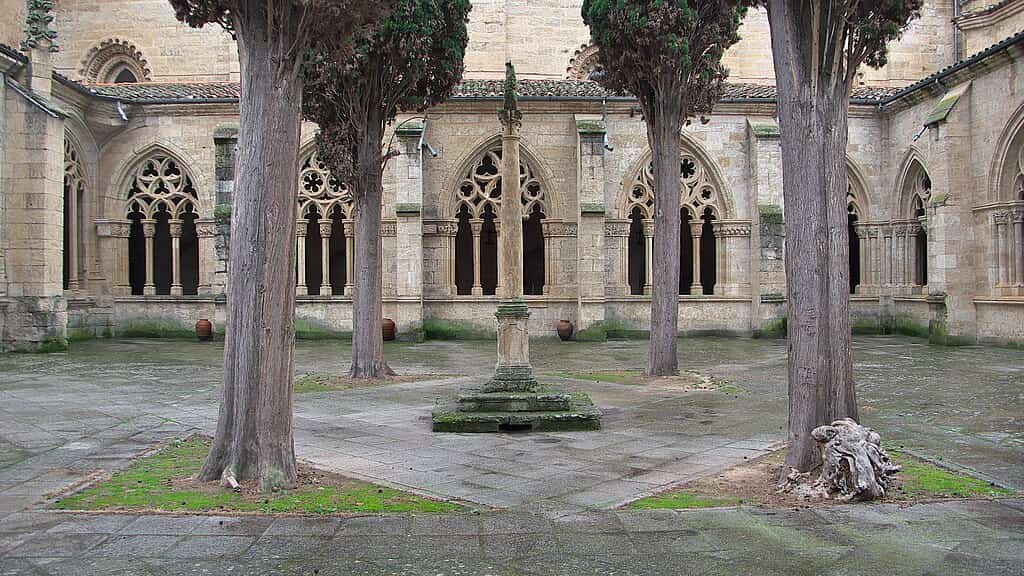
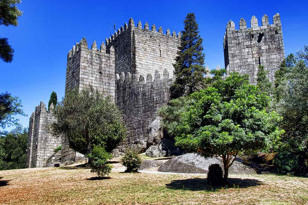
- Guimarães, in Portugal, with a medieval old town.
- Braga, home to the Bom Jesus do Monte sanctuary.
- Tui, with its impressive cathedral-fortress on the Galician-Portuguese border.
- Pontevedra, with its historic old town and seafaring atmosphere.
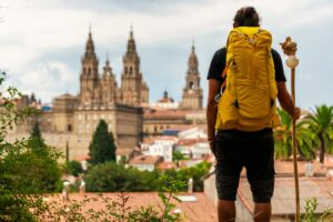
Finally, after about three weeks of walking, the route culminates at the Cathedral of Santiago de Compostela, the ultimate goal of all Jacobean pilgrimages.
A distinctive feature of this route is its historical and cultural richness. The path follows ancient routes such as the Cañada Real de Extremadura, the Roman Road XIX of the Antonine Itinerary (an old Roman road linking Braga with Astorga), and even sections of the Portuguese Way itself.
In fact, it merges with the traditional Portuguese route in Galicia: from Tui to Santiago it shares exactly the same final stages as the central Portuguese Way.
As a less-travelled route than others, it offers an experience of greater peace, nature, and introspection. However, it also requires more preparation and foresight from the pilgrim: some stages are long and cross remote areas, so it’s important to plan accommodation carefully, carry enough water and food, and be in good physical condition.
Waymarking with yellow arrows exists, although it can be scarce in certain stretches; in recent years (2020–2021), new milestones and markers have been installed in parts of the route, but it is advisable to rely on maps or GPS tracks to stay on course.
Stages of the Camino Torres
Below are the 23 proposed stages of the Camino Torres, with their starting and finishing points and the approximate distance of each. This itinerary aims to faithfully recreate the original journey of Don Diego de Torres Villarroel.
- Stage 1: Salamanca – Robliza de Cojos (32.9 km) – Starting at the Cueva de Salamanca (km 0) beside the bust of Torres Villarroel. A long day with virtually no towns along the way, ending in the small village of Robliza de Cojos, which has a pilgrim hostel at the stage’s end.
- Stage 2: Robliza de Cojos – San Muñoz (20.9 km) – A section through the Campo Charro region of Salamanca. The route continues along the Cañada Real among dehesas and cattle pastures. It requires fording streams such as the Arganza, which may mean getting your feet wet during rainy seasons. San Muñoz offers basic pilgrim services.
- Stage 3: San Muñoz – Alba de Yeltes (26.6 km) – A very rural stage. It crosses the dehesa and several riverbanks (Huebra, Yeltes), alternating between tracks and narrow paths among rockrose and holm oaks. Caution is needed in times of high water at fords. Alba de Yeltes is a small village marking the end of the stage.
- Stage 4: Alba de Yeltes – Ciudad Rodrigo (25 km) – After three days through natural surroundings, this stage reaches the first major city. The route follows quiet paved sections (via Bocacara) and paths among cork oaks. The reward is Ciudad Rodrigo, a historic walled city where pilgrims will find a rich monumental heritage.
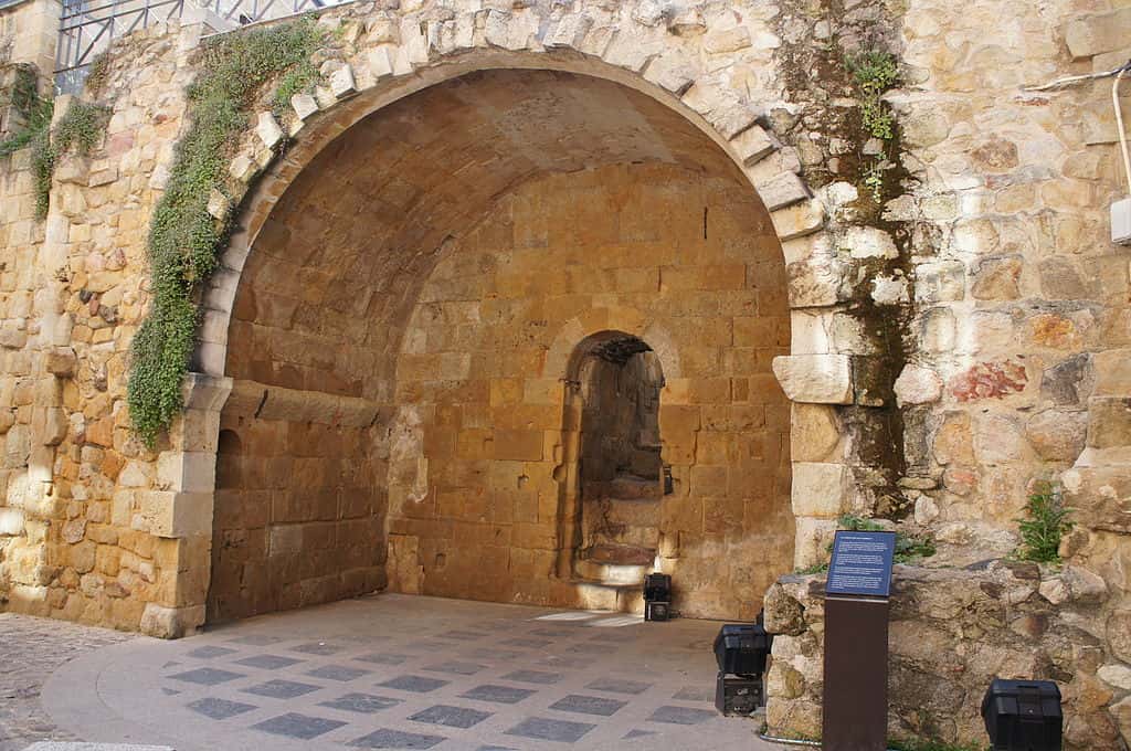
- Stage 5: Ciudad Rodrigo – Aldea del Obispo (30.4 km) – Leaving Ciudad Rodrigo via the medieval bridge over the Águeda River. The route passes through Gallegos de Argañán (Church of Santiago) and Alameda de Gardón before reaching Aldea del Obispo, the last Spanish town. Here stands the Fuerte de La Concepción, an 18th-century fortress next to the Portuguese border.
- Stage 6: Aldea del Obispo – Pinhel (34.1 km) – A long stage marking the entry into Portugal. After crossing the border via the Turones/Tourões River, the route passes through Vale da Mula and reaches Almeida, a famous fortified Portuguese town. From there, the path continues to the city of Pinhel, crowned by its castle.
- Stage 7: Pinhel – Trancoso (30.8 km) – A demanding route with multiple river valleys. Leaving Pinhel, it descends to the Pêga River, then alternates between tracks through vineyards, forests, and small villages. Rivers are crossed via ancient bridges (such as Vale de Mouro), and finally, a last climb leads to Trancoso, a walled medieval town atop a hill.
- Stage 8: Trancoso – Sernancelhe (27.5 km) – From Trancoso, the route descends into the Távora River valley along paths showing remnants of Roman paving. It follows the river, crossing historic bridges (Ponte do Abade) and rural hamlets. Sernancelhe, the stage’s end, is known as “the land of chestnuts” and has a 12th-century Romanesque church.
- Stage 9: Sernancelhe – Moimenta da Beira (19.3 km) – A relatively short stage. The route avoids the N-226 road, climbing up to the sanctuary of Nossa Senhora das Necessidades. It passes through villages like Penso and Arcozelo, amid vineyards and manor houses, before reaching Moimenta da Beira.
- Stage 10: Moimenta da Beira – Lamego (30.0 km) – A tough day with continuous ascents and descents through the Douro region. From Moimenta, it crosses Beira Valente and climbs among vineyards to Sarzedo. After passing Granja Nova, it descends into the Varosa River valley to cross it via the medieval Ucanha bridge (with its fortified Cistercian tower). The path then climbs again through historic villages (Gouviães, Mós) and crosses the Balsemão River to reach Lamego, an important city with a cathedral and sanctuaries.
- Stage 11: Lamego – Mesão Frio (28.4 km) – The route leaves Lamego towards the Douro valley. It first descends to the Varosa River (crossing it via a hidden Roman bridge in a spot known as “Sala do Diablo”), then continues with stunning views over the vineyards of the Alto Douro Vinhateiro (a World Heritage Site). In Peso da Régua, the Douro is crossed on a pedestrian metal walkway. Finally, a steep climb through vineyards leads to Mesão Frio.
- Stage 12: Mesão Frio – Amarante (26.8 km) – A mountainous stage crossing the Serra do Marão. It starts gently along the Teixeira River but soon climbs more than 800 metres to the Alto de Quintela (880 m). From there, a long descent along the old “Estrada Real” leads to the town of Amarante, famous for its São Gonçalo bridge.
- Stage 13: Amarante – Felgueiras (21.2 km) – Already in northern Portugal, this is a shorter stage with moderate elevation. The path links rural villages (Telões, Covelas) and crosses into the municipality of Felgueiras, land of green wines. The stage ends in Felgueiras or nearby (Lixa), before the next historic city.
- Stage 14: Felgueiras – Guimarães (19.3 km) – A short route to Guimarães, known as “the birthplace of Portugal”. The route passes by the Monastery of Santa Maria de Pombeiro and crosses the Vizela River via the Roman-origin Arco Bridge, marking the entrance to the Guimarães district.
- Stage 15: Guimarães – Braga (20.2 km) – Connecting two important medieval Portuguese cities. Leaving Guimarães, it crosses the Roldes medieval bridge over the Selho River. Further on, it reaches Caldas das Taipas, a spa town crossed by the old Roman road to Braga (where the Ara de Trajano, a Roman altar, can be found). After crossing the Ave River via the Ponte das Taipas, the final stretch climbs the Alto de Falperra before descending to Braga, finishing near its famous cathedral.
- Stage 16: Braga – Ponte de Lima (36.1 km) – The longest and most demanding stage. Soon after departure, the Cávado River is crossed via the Prado Bridge. From there, the route coincides in many sections with the Roman Road XIX and the Interior Portuguese Way, sharing signs with both trails. It passes numerous villages (Moure, Goães, Queijada, etc.) before reaching Ponte de Lima, the oldest town in Portugal.
- Stage 17: Ponte de Lima – Rubiães (22.1 km) – From this point, the route coincides with the traditional Central Portuguese Way. This stage is known for the ascent of the Labruja mountains, the greatest climb between Ponte de Lima and Santiago. The day unfolds through pine and eucalyptus forests, with small rural hamlets along the way.
- Stage 18: Rubiães – Tui (19.3 km) – The last stage in Portugal, ending by crossing the border into Spain. The route passes through the fortified city of Valença do Minho on the Portuguese side, walking through its walled enclosure. It then crosses the River Miño via the International Bridge (or a newer pedestrian bridge), entering Tui, Galicia.
- Stage 19: Tui – Redondela (30.0 km) – The first full day in Galicia, and quite a long one. Following the yellow arrows, the route crosses the Louro River valley, passes through the town of Porriño, and later ascends gently to Redondela, on the Vigo estuary. This coastal town is known for its railway viaducts and as the point where pilgrims from the Portuguese Coastal Way merge with those from the Central route.
- Stage 20: Redondela – Pontevedra (15.5 km) – A short stage. The trail follows rural paths and tracks through pine and eucalyptus woods. It passes villages such as Arcade (famous for its medieval Pontesampaio bridge over the Verdugo River) and then continues to the city of Pontevedra.
- Stage 21: Pontevedra – Caldas de Reis (21.5 km) – The route passes through the village of Barro and its vineyards before reaching Caldas de Reis, a town famous for its thermal springs. Caldas takes its name from the hot water fountains that bubble up in the town centre – a perfect spot to relax your feet after the walk.
- Stage 22: Caldas de Reis – Padrón (19.5 km) – The path follows the Ulla River valley, winding through orchards and riverside woods. Passing through the villages of Valga and Pontecesures, the stage ends in Padrón, a key location in the Jacobean tradition: according to legend, the body of the Apostle James arrived here in a stone boat.
- Stage 23: Padrón – Santiago de Compostela (24.3 km) – The final stage. The landscape combines rural areas with Santiago’s suburban surroundings. After leaving Padrón, the route climbs Mount A Escravitude (with its Baroque sanctuary), then reaches Milladoiro (a natural viewpoint offering the first glimpse of the cathedral towers) before finally entering Santiago de Compostela.
Main Points of Interest on the Camino Torres
- Salamanca: Plaza Mayor, Old and New Cathedrals, University, Roman Bridge, and the Cueva de Salamanca – the symbolic starting point.
- Ciudad Rodrigo – Fuerte de La Concepción – Almeida: 18th-century bastioned fortifications that tell the story of the Hispano-Portuguese borderlands.
- Ucanha (medieval bridge and tower) and Lamego: cathedral and the Sanctuary of Nossa Senhora dos Remédios, icons of the Varosa and Douro valleys.
- Guimarães and Braga: historic centres, the Castle of Guimarães, and the Bom Jesus do Monte Sanctuary (UNESCO), jewels of Portuguese heritage.
- Ponte de Lima and Valença–Tui: Roman-medieval bridge over the River Lima and the cathedral-fortress of Tui, with walled enclosures on both sides of the Miño.
The Camino Torres Compared with Other Camino de Santiago Routes
The Camino de Santiago is not a single path but a vast network of historical trails starting from different points across Europe towards Compostela. Each one has its own character, distance, and level of popularity. Below we compare the Camino Torres with other main Jacobean routes to understand its uniqueness within the network:
- French Way (Camino Francés): the most famous and busiest route. It covers around 780 km from Saint-Jean-Pied-de-Port (in the French Pyrenees) to Santiago, generally divided into about 30–35 stages. Crossing northern Spain, it passes through cities like Pamplona, Burgos, and León.
-
- In comparison, the Torres route is far less crowded and offers a more solitary experience. However, both share the same ultimate destination and pilgrim spirit.
- Portuguese Way (Camino Portugués): the second most-travelled route after the French. It traditionally begins in Lisbon (around 600 km to Santiago) or you can also take the route from Porto to Tui.
-
- As mentioned, the Torres shares with the Portuguese route its Hispano-Lusitanian character. In fact, they converge in Tui and follow the same path to Santiago. However, the Torres passes through inland Portuguese regions not covered by the central Portuguese route (such as Pinhel, Trancoso, Lamego, etc.).
In addition to these main variants, there is the Spiritual Variant, between Pontevedra and Vilanova de Arousa, which includes a boat journey along the Arousa estuary to Padrón.
All these Portuguese routes are well-marked and serviced, reflecting their growing popularity. The Camino Torres remains a more authentic and solitary path, ideal for pilgrims who value history and adventure.
- Other notable routes include the Northern Way (Camino del Norte) (around 820 km following the Cantabrian coast) and the Primitive Way (Camino Primitivo) (about 320 km from Oviedo).
-
- By comparison, these routes also offer spectacular landscapes and fewer crowds than the French Way, although they are busier than the Torres. They are well-equipped with services and signage, whereas the Torres, being newer, still includes sections where pilgrims must be more self-sufficient.
- The Vía de la Plata stretches over 700 km to Astorga, where it joins the French Way, or continues as the Sanabrés Way towards Santiago. It was the alternative route that Don Diego de Torres chose to avoid in 1737, preferring to travel through Portugal. Today, the Vía de la Plata is a very long route, less frequented in summer due to the heat, yet rich in Roman heritage.
-
- Its continuation, the Sanabrés Way from Ourense, starts from Granja de Moreruela or Ourense (the last ~110 km) to Santiago, avoiding the need to pass through Astorga.
Interestingly, the Camino Torres is almost a hybrid: it begins in Salamanca (a city on the Vía de la Plata) but instead of continuing towards Zamora–Ourense, it turns into Portugal to later join the Portuguese Way.