The Inca Trail to Machu Picchu combines history, nature, and physical challenge. Comparing it to the Camino de Santiago helps to understand two great pilgrimage routes that transform those who dare to walk them.
Índice de contenidos
- 1 A sacred path in the Andes: the origin and history of the Inca Trail
- 2 What the Classic Inca Trail is like
- 3 Weather, best season, and level of difficulty
- 4 Inca Trail logistics: permits, guides, and accommodation
- 5 Inca Trail and Camino de Santiago: practical comparison and similar routes
- 6 Emotional and spiritual links between the Inca Trail and the Camino de Santiago
A sacred path in the Andes: the origin and history of the Inca Trail
The Qhapaq Ñan, the great Inca road network
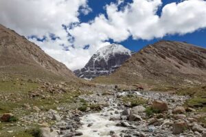
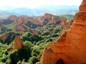
The so-called Inca Trail to Machu Picchu is actually a small section of a much larger network: the Qhapaq Ñan, the imperial highway that connected the territories of the Tahuantinsuyo from Colombia to Chile. This network eventually spanned over 30,000 kilometers of stone paths, stairs, hanging bridges, and roads that crossed valleys, jungles, and Andean mountains.
Within this network, the most famous section today is the one that connects the Sacred Valley with Machu Picchu. It is a 42–43 kilometers trail with cobbled paths, terraces, and stairways that have been well preserved enough to walk almost “in the footsteps” of ancient Inca messengers and nobles.
At the time, this path was not a tourist route, but a ceremonial road that allowed controlled access to an important sanctuary. Today, both the Qhapaq Ñan and Machu Picchu are declared World Heritage Sites by UNESCO, recognizing their immense historical, architectural, and scenic value.
Machu Picchu as a ceremonial destination
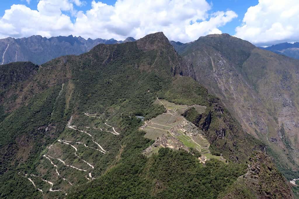
Machu Picchu, built in the 15th century, is believed to have functioned as a sacred citadel and seasonal residence for the Inca elite, in addition to having a strong astronomical and ritual component. The arrival via the Inca Trail culminates at the Sun Gate (Inti Punku), an elevated point from which the site is viewed as a perfect setting surrounded by mountains and jungle.
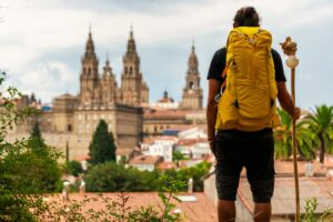
For today’s hiker, just as for the ancient inhabitants of the Andes, the route to the sanctuary is not just a physical journey: it is a ceremonial approach. The effort of several days makes the entrance here have a strong emotional impact, similar to what a pilgrim feels when they first glimpse the towers of the cathedral in Santiago after many kilometers on foot.
What the Classic Inca Trail is like
Total distance, altitude, and terrain type
The Classic Inca Trail is the most well-known version. It covers about 42–43 km in 4 days and 3 nights, always camping within the Archaeological Park.
- Maximum altitude: Abra Warmiwañusca, around 4,200–4,215 m above sea level.
- Minimum altitude: Aguas Calientes / Machu Picchu area, around 2,100–2,200 m.
caminoincamachupicchu.org
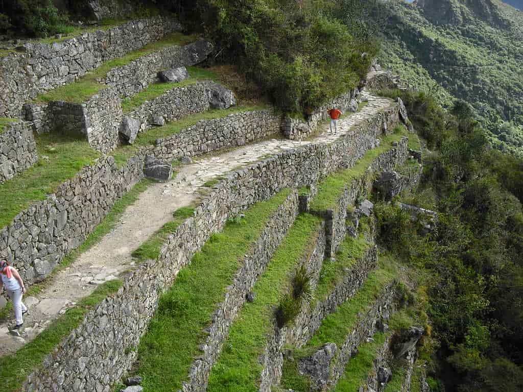
The terrain combines dirt paths with long stone staircases built by the Incas. There are sections that are smooth and others that are very steep, both uphill and downhill. It is not a technical route, but it is demanding if you are not used to walking at high altitudes.
Day 1: from km 82 to Wayllabamba
Typically, the starting point is Cusco or the Sacred Valley, and from there, you drive to km 82 (Piscacucho), at an altitude of about 2,700–2,800 meters, where the entrance control is located.
- Approximate distance: 11–13 km.
- Final altitude: Wayllabamba campsite (~3,000 m).
- Difficulty: easy to moderate.
This is a day intended as an introduction: you walk along the Urubamba River, visit the first ruins (such as Llactapata), and progress through fields and small Andean communities. The lack of oxygen is not yet very noticeable, but it is important to go slow and drink plenty of water.
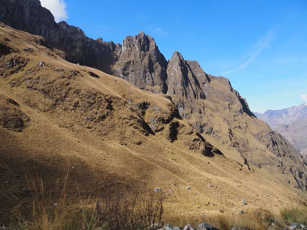
Day 2: the challenge of Abra Warmiwañusca (Dead Woman’s Pass)

The second day is, for many, the toughest and yet the most memorable. From Wayllabamba, you continuously ascend to Abra Warmiwañusca, also known as Dead Woman’s Pass, the highest point on the trail (about 4,215 m).
- Elevation gain: around 1,200 m of accumulated ascent.
- Approximate distance: 10–11 km to Pacaymayo.
- Difficulty: challenging.
It is a long natural staircase that requires patience, a slow pace, and good acclimatization. After reaching the pass, you descend to the Pacaymayo campsite (~3,500 m). Despite the effort, the views of the valleys and Andean peaks make many consider this the most epic day of the route.
Day 3: ruins in the cloud forest
The third day is the longest, but it feels more manageable because the elevation gain is more evenly distributed and there are alternating ascents and descents.
- Altitudes: you cross two secondary passes (Runkurakay and Phuyupatamarca, above 3,600 m) and descend into the cloud forest.
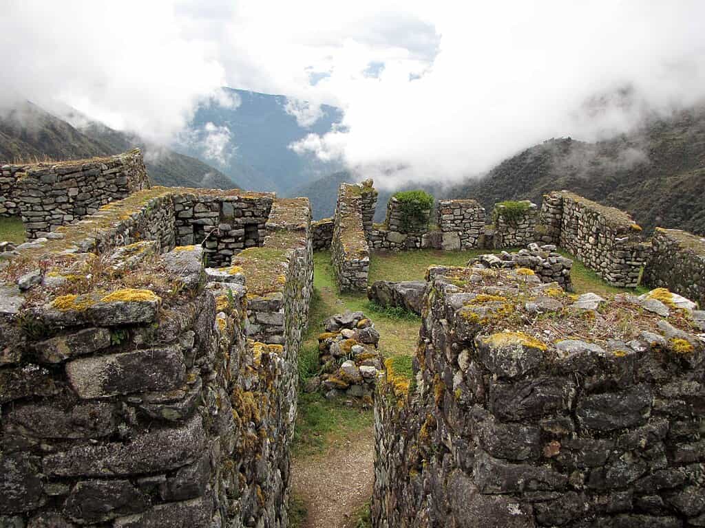
On this day, you visit several spectacular Inca ruins like Sayacmarca, Phuyupatamarca, and, near the end, Wiñay Wayna, a terraced citadel hanging over the valley. Many of these structures are only accessible by walking the Inca Trail, which gives the feeling of entering “a secret outdoor museum.”
El terreno ya es clearly jungle-like: high humidity, lush vegetation, orchids, ferns, tropical birds… and, with luck, the odd elusive Andean mammal.
Day 4: arrival at Machu Picchu via the Sun Gate

The final day begins very early, usually around 3:30–4:00 a.m., in order to arrive in time for sunrise. From the Wiñay Wayna campsite, you walk around 5–6 km to the Sun Gate (Inti Punku), at roughly 2,700 m in altitude.
After one last steep section of steps, the trail opens onto a natural viewpoint from which, if the mist allows, Machu Picchu appears illuminated by the first light of the day. Afterwards, you descend to the citadel for the guided visit and eventually continue down to Aguas Calientes to return by train to the Sacred Valley or Cusco.
Weather, best season, and level of difficulty
Dry season and rainy season
Around Machu Picchu there are two main seasons:
- Dry season: from May to September, with less frequent rainfall and more stable skies. This is the most recommended period for safety and visibility.
- Rainy season: from November to March, when heavy showers, dense fog and wetter, more slippery paths are common.
Additionally, the Inca Trail remains closed in February for maintenance and conservation work, even though Machu Picchu continues to receive visitors by train during that period.
The month of May is especially recommended. Besides being relatively dry, the landscape is particularly green after the rains.
Altitude acclimatisation and physical preparation
One of the major challenges of the Inca Trail is the altitude. Cusco sits at around 3,400 m and the highest point of the trek reaches 4,200+ m. At this elevation, it is normal to feel short of breath, notice a faster heartbeat and experience extra fatigue, even for people used to physical exercise. Therefore, it is recommended to:
- Spend 2–3 nights beforehand in Cusco or the Sacred Valley before starting the trek.
- Avoid alcohol and very heavy meals during the first few days.
- Drink water frequently and, if you wish, coca tea (a traditional Andean practice).
It is advisable to train beforehand with several-hour walks and some elevation gain so that your body is used to prolonged effort.
Real difficulties: effort, gradients, and waymarking
As for physical effort, the trek is usually rated as moderate to demanding: it does not require climbing experience or special techniques, but it does require good fitness and, above all, consistency. The combination of steep gradients, irregular stone staircases and altitude is what makes the route physically intense.
In terms of waymarking, the trail is quite clear (it is a single valley-path without major junctions) and is within a controlled environment. In this case, you will not walk following arrows but alongside a professional guide who sets the pace, manages timings, and ensures the safety of the group.
Inca Trail logistics: permits, guides, and accommodation
Limited permits and February closure
The Inca Trail is a heavily regulated area. The Peruvian government limits access to 500 people per day, a number that includes hikers, guides, porters and cooks. This means that, in practice, only around 200–250 walkers can enter each day. The permits:
- Are managed exclusively through authorised agencies.
- Are personal, non-transferable and sell out months in advance during high season.
- Cannot be bought on arrival: you must book the trek in advance (ideally at least 6 months beforehand).
Furthermore, as already mentioned, the trail closes in February for maintenance, meaning there are no trek departures that month, although Machu Picchu can still be visited by alternative means.
Agencies, porters, and campsites
Unlike the Camino de Santiago, the Inca Trail cannot be done independently: regulations require you to join an authorised agency, which provides:
- Official guides (usually bilingual Spanish/English).
- Porters who carry tents, kitchen equipment, and part of the shared gear.
- Cooks and logistical staff.
- All camping infrastructure (tents, tables, chairs, etc.).
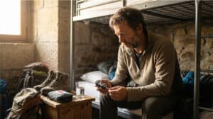
Accommodation is always in pre-assigned official campsites. There are no hotels; you sleep in tents, generally on a full-board basis, and the group progresses like a small Andean expedition.
What to pack and what to expect from the experience
In general, it is recommended to bring:
- A comfortable daypack (20–30 litres).
- A high-quality sleeping bag (many agencies offer rental options).
- Worn-in hiking boots, trekking poles, headtorch, sunscreen and a rain jacket.
- Layered clothing, including warm gear for cold nights at altitude.
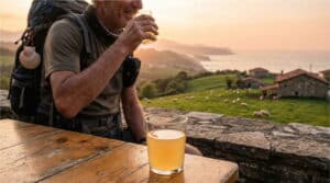
From a logistical perspective, the experience feels almost like an “organised trek”: the walker focuses solely on hiking, while a local team handles cooking, campsite setup and heavy loads. This contrasts greatly with the more independent, village-to-village European style of the Camino de Santiago.
Inca Trail and Camino de Santiago: practical comparison and similar routes
Here we look directly at the relationship with the Camino de Santiago, focusing on how the Inca Trail feels if you already have experience on the Caminos—or if you are thinking of doing both.
Camino Francés
- The Inca Trail is shorter but more intense due to the altitude.
- Logistics are more rigid (guided group and camping) compared with the full freedom of the Francés, with hostels and flexible schedules.
- Both culminate in a World Heritage Site of immense symbolic value: Santiago and Machu Picchu.
Portuguese Camino (Porto–Tui)
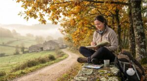
The Portuguese Camino from Porto to Tui totals around 115–120 km, typically walked in 5–7 stages along gentle, well-marked terrain. If you are considering a “one-week section” to compare with the Inca Trail, this is the most natural parallel: less elevation gain, more kilometres, towns and cities each day, but without the challenges of altitude.
Specialised websites offer organised options where you walk with a light daypack, staying each night in accommodation with hot showers, restaurants and all services. Physically it is more accessible than the Inca Trail, but being spread over more days requires consistency and care for your feet, joints and rest.
Spiritual Variant of the Portuguese Camino
The Spiritual Variant of the Portuguese Camino offers roughly 70 km between Pontevedra, Armenteira, Vilanova de Arousa and the boat journey along the estuary to Padrón. It is organised in 3–4 stages, one of them by sea, recreating the legendary Traslatio of the apostle’s remains.
It is a short route, with moderate elevation, centred strongly on the spiritual and scenic experience (woodlands, monasteries, vineyards and the estuary). From a hiker’s perspective, it may recall the gentler part of the Inca Trail (day 3–4), but without altitude or acclimatisation needs.
Camino Primitivo
The Camino Primitivo covers around 310–320 km in 12–14 stages. It is considered one of the toughest routes of the Caminos due to constant elevation changes in the Asturian-Galician mountains, although without Andean altitudes.
Those who have completed the Primitivo may perceive the Inca Trail as a distant cousin: fewer kilometres but more concentrated gradients and, above all, less oxygen. Both share one characteristic: the feel of “real” mountain walking and a less crowded path.
Camino del Norte
The Camino del Norte follows the Cantabrian coast for about 800 km and more than 30 stages. Its difficulty comes from the continuous up-and-down terrain and unpredictable weather (rain, wind, hot days).
Compared with the Inca Trail, it offers more variety of human landscapes (beaches, cities, fishing ports) and less sense of natural isolation. The Inca Trail is, in this sense, far more “wild”: four days immersed almost entirely in mountains and jungle, without intermediate villages.
Camino Sanabrés (Ourense–Santiago)
If you are looking for a comparison in duration, the Camino de Santiago Ourense to Santiago is a good benchmark. From the thermal city to Santiago there are about 110 km, usually divided into 5–6 stages across inland Galicia.
It is a route with a moderate number of pilgrims, reasonable ascents and a calm rural atmosphere. Physically it is much gentler, but also “longer” in days. Here you walk from village to village, staying in hostels and guesthouses, while on the Inca Trail you are always camping at high altitude.
Role of Camino de Santiago companies versus Inca Trail logistics
Along the Camino de Santiago, a whole network of specialised services has emerged: luggage transport, accommodation bookings, local guides, etc. Many of these solutions are centralised through Camino de Santiago companies that help those who want to focus solely on walking, in a similar way to how trekking agencies manage all logistics on the Inca Trail.
The key difference is that, while on the Camino de Santiago these services are optional (you can do everything on your own if you wish), on the Inca Trail the involvement of an authorised agency is mandatory by regulation: without a guide and pre-arranged permits, you simply cannot enter the trail.
Emotional and spiritual links between the Inca Trail and the Camino de Santiago
Inner journey, rite of passage, and connection with the landscape
Beyond the numbers, maps and elevation data, both paths share something fundamental: the experience of an inner journey. For several days, life is reduced to the essentials: walk, eat, sleep, repeat. Such simplicity opens space for reflection, taking stock, healing grief or simply enjoying the present moment.
- On the Inca Trail, the overwhelming presence of the mountains, the early-morning mist lifting, and the ruins emerging from the vegetation remind you that you are in a sacred place centuries old. Many hikers describe the route as a “transformative” experience, where physical challenge, natural beauty and Inca history leave a profound mark.
- On the Camino de Santiago, spirituality is experienced differently: Romanesque churches, crosses, monasteries, towns that have welcomed pilgrims since the Middle Ages… and above all the pilgrim community, that feeling of walking with people from all over the world with very different motivations but one shared destination. Even without religious faith, many describe arrival at the Plaza del Obradoiro as a moment of catharsis.
In both cases, there is something of a rite of passage: you enter one way and leave another, with the feeling of having crossed a symbolic threshold.
Community, memory, and personal transformation
On the Camino de Santiago, the community is built day by day: you share accommodation, dinners, conversations, and see the same faces reappear across different stages. This small family is one of the strongest memories pilgrims take home.
On the Inca Trail, the group is usually smaller (around a dozen walkers), but the intensity of living together at altitude, camping, shared meals and the collective achievement of crossing Abra Warmiwañusca create a very special bond. It is common for walkers to stay in touch afterwards, having lived an experience that is not easily forgotten.
Both paths also bring personal transformation: greater confidence in your physical and mental abilities, deeper respect for nature and for the cultures that lived in these lands long before us.