The Finisterre Way is a unique extension that leads pilgrims from Santiago de Compostela to Cape Finisterre, once known as “the end of the world”. Although it is a relatively short route (around 87 km in total), many walkers wonder whether it is demanding and which of its stages present the greatest challenges.
In this guide we will analyse the difficulty of the Finisterre Way, comparing it with other Jacobean routes. We will outline the factors that influence its level of difficulty and describe the toughest stages (as well as the easiest ones) on this itinerary towards the Costa da Morte.
Índice de contenidos
Difficulty of the Finisterre Way vs. other Camino de Santiago routes
To assess how difficult the Finisterre Way is, it is useful to compare it with other Jacobean routes (you can consult this Camino de Santiago guide for general information on all the routes). Overall, it is a manageable and moderately difficult route, especially when compared with longer or more mountainous itineraries. Below, we take a look at how it sits alongside other routes:
- French Way: this is the most popular route (almost 800 km from the Pyrenees). Although it has certain tough stages –such as the ascent over the Pyrenees on the first day or the climb up to O Cebreiro in Galicia– it is considered of medium difficulty. It is very well equipped with services and frequent hostels, which makes progress easier. By comparison, the Finisterre Way is much shorter and does not reach such high altitudes, so its overall physical demand is lower.
- Primitivo Way: known for being one of the toughest, it crosses mountainous areas of Asturias and Lugo. It includes steep gradients (for example, the Route of the Hospitals) and demanding stages almost daily. By contrast, the Finisterre Way has barely any significant climbs; there are no major mountain passes, making it much easier to manage.
- Northern Way: this coastal route alternates constant ups and downs. Although it does not reach very high peaks, the relentless rollercoaster terrain of the North accumulates fatigue day after day. Meanwhile, the route to Finisterre runs through gentle hills and valleys in Galicia; aside from some occasional slopes, it does not punish the legs nearly as much.
- Portuguese Way (central route): this is one of the easiest routes in terms of terrain, especially in its final stretch from Tui to Santiago, which is practically flat. For a beginner, walking the Oporto to Tui Portuguese Way means short, comfortable days. If starting further back, from Porto, the difficulty increases slightly (there is a demanding uphill section in Portugal, such as the climb to Alto da Labruja after Ponte de Lima). Even so, the overall profile is gentle.
-
- Spiritual Variant (Translatio): this is a special 3-stage detour within the Portuguese Way combining mountain paths and a boat section. The Spiritual Variant Translatio is slightly more physically demanding than the traditional Portuguese Way, especially due to the steep climb up to Armenteira Monastery on the stage between Pontevedra and Armenteira. However, the rest of this variant is manageable (it even involves sailing along the Arousa estuary), and overall the difficulty remains moderate.
- English Way: from Ferrol to Santiago there are around 118 km split into 5 stages. It is a short route with moderate gradients (there is a notable climb into inland Galicia after the initial coastal stretch). Its difficulty could be considered medium. Both routes share reasonable daily distances and some short but steep climbs, though without extremes.
- Sanabrian Way: the final section of the Silver Route from Ourense (approx. 105 km) is done in 5 stages similar in length to those of Finisterre. The Ourense to Santiago stages have a medium level of difficulty, with a demanding initial climb on leaving Ourense (several hundred metres of ascent in just a few kilometres). After that steep climb, the rest of the route unfolds through rolling terrain and rural villages.
In summary, the Finisterre Way is very accessible even for beginners. It involves very little difficulty compared with longer or more mountainous routes, making it easy to complete. In fact, many choose it to round off their Jacobean experience after arriving in Santiago.
Factors that define the difficulty of the Finisterre Way
Although this route is not among the toughest overall, it is worth understanding in detail which aspects can make it more or less demanding:
- Physical effort and terrain profile: it is mostly flat or gently undulating. There are no major mountains to climb; the gradients are moderate and short. Along the route you will encounter tarmac stretches, rural paths and dirt tracks.
-
- In the first half (between Santiago and the Mazaricos region) the terrain alternates forests, rivers and small climbs, but none of the gradients are insurmountable for a walker with basic fitness.
-
- In the second half, approaching the coast, there are some more noticeable slopes (for example on reaching certain “altos” or small passes), but again they are short hills. Overall, if you walk at a steady pace, the profile will not overly strain your legs.
- Total distance and stages: from Santiago to Finisterre there are around 87 km in total, usually divided into 4 or 5 walking stages. This means covering an average of 18–22 km per day. Bear in mind that if you try to complete it in only 4 days (from Negreira to Olveiroa), there will be at least one stage exceeding 30 km, which does indeed increase the level of difficulty significantly.
- Main slopes and challenging stretches: Although there are no mountains, there are a couple of climbs worth noting.
-
- On the 1st stage you climb up to Alto do Vento (around 275 m altitude) halfway through the route. It is a prolonged ascent of several kilometres that can be felt, especially if you are not yet warmed up or arrive tired from a previous Camino.
-
- Further on, on the 4th stage from Olveiroa to Cee, you reach the high point of Cruceiro da Armada/Hospital before descending to the sea: the descent into Cee is steep and requires caution, as it can strain the knees.
-
- On the 5th and final stage there are small continuous ups and downs along the coast (especially leaving Corcubión and on the final stretch to the Finisterre lighthouse).
- Signposting and orientation: The Finisterre Way is well signposted. You will find the familiar yellow arrows and stone markers with the scallop shell along the entire route, just like on other Caminos. Leaving Santiago Cathedral, the arrows can initially be a bit discreet (you need to look carefully to take the correct direction towards Finisterre), but once outside the city the markers showing the kilometres remaining soon appear.
From San Lorenzo Park onwards, the kilometre markers are continuous right up to Finisterre (in fact, they also indicate the fork should you wish to go to Muxía). Thanks to this excellent signposting, it is not easy to get lost: even without GPS or maps you can follow the route with confidence.
- Infrastructure and accommodation: the route to Finisterre crosses rural areas with a lower density of villages and hostels. However, this does not mean you will be left without a place to stay: there are multiple accommodation options available at each typical stage end. Towns such as Negreira, Olveiroa, Cee and Finisterre offer hostels, guesthouses or hotels where pilgrims can rest and regain strength without difficulty.
In the intermediate stretches between these main stops there are indeed fewer services, so it is generally wise to plan your rests at these key towns.
Other additional factors such as the weather can also influence how hard the stage feels: in Galicia, rain and wind are common, especially when approaching the coast. A day of intense heat or a heavy downpour can make a stage more challenging when it would be easy in dry conditions. Fortunately, temperatures in this region are generally mild for most of the year.
The toughest stages of the Finisterre Way
Now that we understand the route as a whole, let’s identify three specific stages that stand out as the most demanding on the Finisterre Way. Although none of them are extreme, these days present greater challenges due to distance, elevation or terrain. Below we describe each one in detail:
1. Stage Santiago de Compostela – Negreira (21 km, moderate difficulty)
Why it’s tough: this is the first stage and, for many pilgrims, it means getting back into walking mode after having completed the main Camino into Compostela.
Around halfway through comes the longest climb of the entire route: the ascent to Alto do Vento. It is roughly 3 km of continuous uphill, gaining around 200–250 metres in elevation. This climb can be hard if your legs are tired or if you don’t pace yourself properly, as it is steady and appears after you’ve already walked around 11–12 km.
Stage description: after leaving behind the Plaza do Obradoiro, the Camino soon becomes peaceful: you pass through suburban neighbourhoods and descend into woods and green corridors along the River Sar. The scenery becomes more beautiful with each kilometre, shifting from the cityscape to picturesque Galician rural surroundings.
The midpoint of the day roughly coincides with km 79 (79 km remaining to Finisterre), where there is usually a bar or rest area –a recommended stop to catch your breath. Immediately afterwards, the climb up to Alto do Vento begins, zigzagging along forest tracks. The slope becomes quite steep, so it’s wise to take it easy, drink water and take short breaks if necessary.
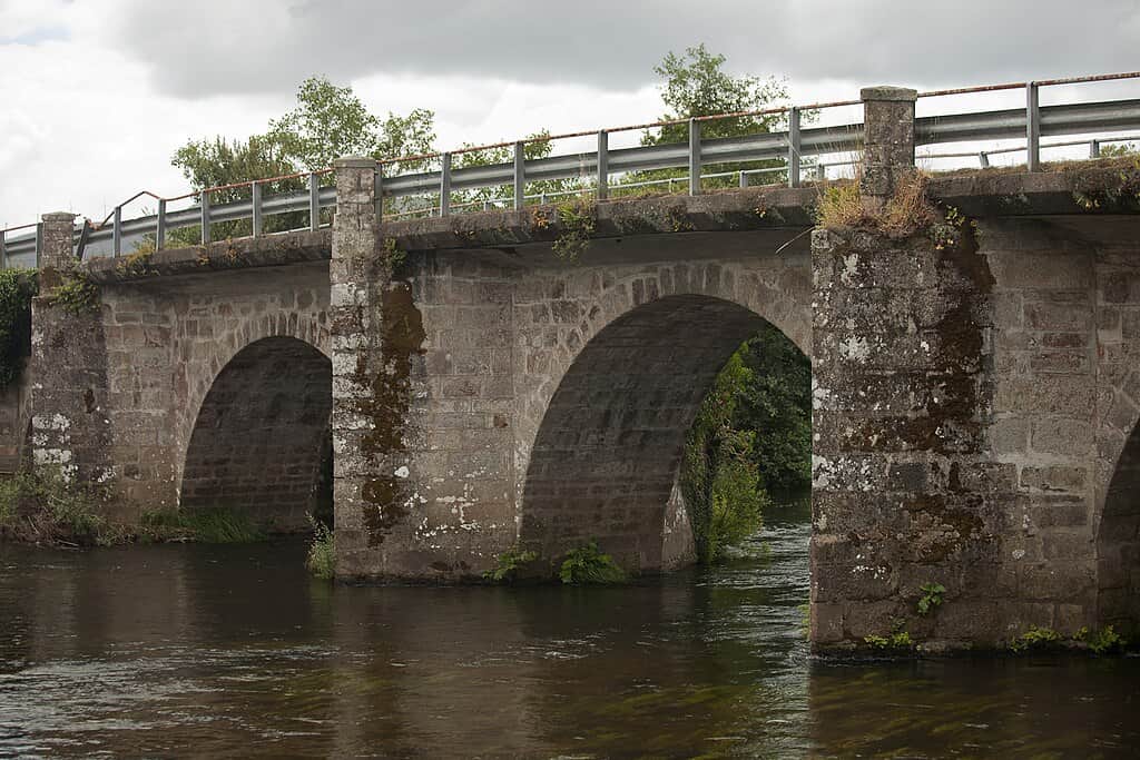
From that point onwards, the rest of the stage is more manageable. Woodlands of oaks alternate with traditional hamlets and flat or descending stretches. A landmark on the way is Ponte Maceira, a medieval stone bridge over the River Tambre, whose scenery is very photogenic.
After crossing it, pleasant paths continue until reaching Negreira. This town offers all services and is an ideal place to rest after this first day, which overall can be classified as moderate.
2. Stage Olveiroa – Cee (18 km, moderate difficulty)
Why it’s tough: this fourth day (in a 5-day plan) includes two particular challenges: a gradual ascent at the beginning and, more importantly, a steep and prolonged descent at the end. Although the distance is not very long (about 17–18 km), many pilgrims highlight the descent into Cee as one of the physically hardest sections, as it is long and very steep.
Descents can be treacherous: after several days of walking, muscles and joints (especially knees and ankles) suffer on negative gradients. For this reason, this stage deserves to be listed among the toughest despite its moderate distance.
Stage description: the day begins in Olveiroa. On leaving the village, the route gradually climbs through increasingly open landscapes. You leave the lush interior behind and enter slightly drier, almost semi-mountain terrain.
The climb is not extremely steep, but it is continuous over several kilometres until reaching the area of Alto do Hospital (named after the ruins of an old pilgrims’ hospital). The sensation is one of solitude and transition: suddenly, on reaching the top, the pilgrim feels they are crossing from inland Galicia to the coastal world.
After this high point, the descent begins and with it the first views of the Atlantic Ocean. At O Cruceiro da Armada there is a natural viewpoint from which, on clear days, you can see the Corcubión estuary, Cape Finisterre in the distance, and the vast blue of the sea.
However, the most physically demanding part is still ahead: the final descent. The path drops down through woods and meadows, losing height quickly. You must proceed with caution, as the terrain can be rocky or slippery. Many pilgrims slow their pace here to avoid straining their knees. Trekking poles, if you have them, are extremely helpful for balance and support.
Once reaching sea level, you enter the town of Cee, the end of the stage. Cee already has a maritime atmosphere and offers all necessary services. The sensation at the end of this day is bittersweet: on one hand, your legs may feel exhausted from the demanding descent; on the other, the sight of the ocean and knowing you are now beside the sea gives a huge emotional lift.
3. Stage Cee – Finisterre (15 km, medium difficulty)
Why it’s tough: although it is the final stage and the shortest in distance (around 15 km), it should not be underestimated. Fatigue from previous days may be noticeable, and this stage features several short climbs and descents that can catch you off guard.
In addition, many pilgrims extend the walk a few extra kilometres to reach the Finisterre Lighthouse, which sits beyond the town on top of a headland. That final climb to the lighthouse, after arriving in Fisterra, adds extra effort. Overall, it is not technically difficult, but it is emotionally intense and includes some hills that test your endurance in the final stretch of the journey.
Stage description: from Cee, the Camino initially runs along the sea. There is a beautiful coastal promenade connecting Cee with neighbouring Corcubión, along a practically flat route that borders the estuary. This beginning is very pleasant, with the sea breeze accompanying the pilgrim.
Leaving Corcubión, the scenery changes: it’s time to say goodbye to sea level for a while and tackle a climb towards the interior of the Finisterre peninsula. It is an ascent along road and path that offers panoramic views of the coast as height is gained. It isn’t extremely long, but it is steep in parts. Once this hill is conquered, the route crosses woods and small hamlets.
Soon comes the last major descent: the path slopes down towards Langosteira Beach, a long white-sand beach that stretches to the entrance of the town of Finisterre itself. Many pilgrims choose to walk for a while along the shore, even take off their shoes and dip their feet into the cold Atlantic as a symbolic act of purification. From the far end of Langosteira, the first houses of Fisterra (Finisterre) come into view.
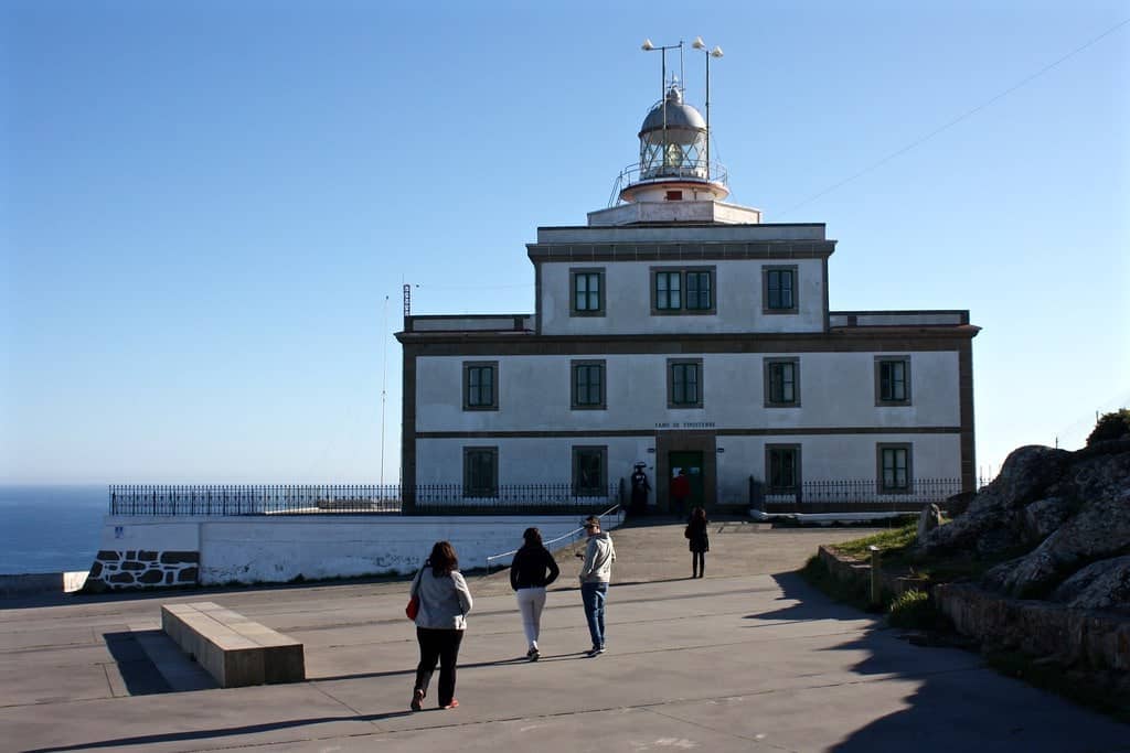
Technically, the walk ends in the town centre of Finisterre, where you can obtain the “Finisterrana” (certificate of arrival). However, most pilgrims feel their journey is not complete until they walk the additional 2–3 km to the Finisterre Lighthouse, located on the cape and marked with the iconic Km 0.00 milestone.
This final climb to the lighthouse is done via tarmac road or shortcuts along the hillside. It takes about 20–30 minutes of steady ascent, with fatigue already accumulated but driven by excitement. Upon reaching the top, the landscape and symbolism of the place make all the effort worthwhile: the vast Atlantic Ocean before your eyes and the feeling of having literally reached “the end of the Earth”.
In short, the stage from Cee to Finisterre may seem easy because of its short distance, but it includes several gradients and the accumulated fatigue of the entire route. Even so, the motivation of being about to finish pushes many to complete it without difficulty. It is a stage to savour step by step, despite the hills, and to end with an unforgettable sunset at the lighthouse.
The easiest stages of the Finisterre Way
Not everything on this route is demanding; there are also stages that are particularly easy and relaxing, allowing you to recover energy and enjoy the surroundings without rushing. On the Finisterre Way, one day stands out as the easiest:
Stage Maroñas (Santa Mariña) – Olveiroa (approx. 13 km, low difficulty): this is the third stage if doing the route in 5 days. It is notably shorter than the others, designed specifically to divide what was once done in a single long stretch. With around 13–14 km of practically flat terrain, this walk can be completed in half a day.
The route runs along rural paths, through small hamlets and bucolic landscapes, with no significant climbs. Many pilgrims choose to take this stage very calmly: leaving later, stopping by streams, chatting with other walkers, or simply admiring the hórreos and rural churches along the way.
Upon reaching Olveiroa before lunchtime, you have the entire afternoon to rest in this peaceful village. This day acts almost as a “recovery day”, preparing the legs for the longer final stages. Without a doubt, it is the easiest and shortest stage of the Finisterre Way, perfect for relaxing.
Another relatively manageable stage is Negreira – Maroñas, about 20 km, which is the second day on the 5-day itinerary. Its profile is medium-low difficulty: although 20 km still requires effort, it does not present major climbs (just some gentle undulations), and the terrain is quite friendly. After tackling the Alto do Vento climb the day before, this stage feels easier in comparison. Overall, both Stage 2 and Stage 3 allow the pilgrim to find their rhythm without excessive strain.
In summary, the Finisterre Way combines moderately demanding days with some very easy ones. Alternating tough stages with easier days is part of its balance, making the route varied and manageable. Many pilgrims especially appreciate the short Maroñas to Olveiroa stage to recharge and enjoy the journey at a leisurely pace.